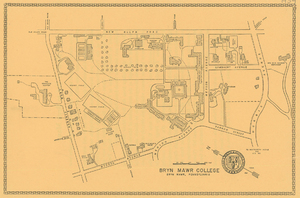
Bryn Mawr College Campus Map, 1937
Dublin Core
Title
Bryn Mawr College Campus Map, 1937
Subject
Bryn Mawr College, Universities & Colleges
Maps
Maps
Description
Aerial Map of Bryn Mawr Campus and surrounding area (original)
Millbank Road
Caversham Road
Pembroke Road
Old Gulph Road
New Gulph Road
Low Buildings
Tennis Courts
Radnor
Gymnasium
Parking Area
Merion
Denbigh
Dalton
Cartref
The Pagoda
Infirmary
Parking Area
Power House
Taylor
Pembroke East
Dolgelly
College Inn
East House
Mrs. Otis Skinner Workshop
Senior Row
Merion Avenue
Lombaert Avenue
Morris Avenue
The Graduate Center
Hockey Field
Parking Area
The Deanery
The M. Carey Thomas Library
Pembroke West
Wyndham
Roberts Road
Hockey Field
Faculty Row
Tennis Courts
Tennis Courts
Rhoads North
Rhoads South
Goodhart
Rockefeller
Ashbridge Road
Applebee Barn
West House
Yarrow
President’s House
Wyndon Avenue
Merion Avenue
Yarrow Street
To Montgomery Avenue and U.S. 30
Kennedy Lane
Bryn Mawr College
Bryn Mawr, Pennsylvania
[Text on Map]
Old Gulph RoadMillbank Road
Caversham Road
Pembroke Road
Old Gulph Road
New Gulph Road
Low Buildings
Tennis Courts
Radnor
Gymnasium
Parking Area
Merion
Denbigh
Dalton
Cartref
The Pagoda
Infirmary
Parking Area
Power House
Taylor
Pembroke East
Dolgelly
College Inn
East House
Mrs. Otis Skinner Workshop
Senior Row
Merion Avenue
Lombaert Avenue
Morris Avenue
The Graduate Center
Hockey Field
Parking Area
The Deanery
The M. Carey Thomas Library
Pembroke West
Wyndham
Roberts Road
Hockey Field
Faculty Row
Tennis Courts
Tennis Courts
Rhoads North
Rhoads South
Goodhart
Rockefeller
Ashbridge Road
Applebee Barn
West House
Yarrow
President’s House
Wyndon Avenue
Merion Avenue
Yarrow Street
To Montgomery Avenue and U.S. 30
Kennedy Lane
Bryn Mawr College
Bryn Mawr, Pennsylvania
Publisher
Bryn Mawr College
Date
1937
Rights
Image courtesy Bryn Mawr College Special Collections
Format
jpg
2048 x 1425
2048 x 1425
Language
English
Type
Image
Identifier
CMPA00006_BMC_f.tif
Coverage
Bryn Mawr, PA
1937
1937
Still Image Item Type Metadata
Original Format
Paper
Files
Reference
Bryn Mawr College Campus Map, 1937, Bryn Mawr College, 1937

