Traveling by Car
Segregation by Car
For Black travelers, travel by car was more arduous than for white travelers. To begin with, African Americans were and are statistically less likely to own cars, a fact which today perpetuates racially-associated areas of poverty, as Black and Latino workers are left physically isolated from areas of employment.1 African Americans were not well represented within the automobile industry, either; in all of American history, there has been only one Black owned and operated automobile company, C.R. Patterson & Sons, in Greenfield, Ohio, which constructed and sold the Patterson-Greenfield automobile from 1915 to 1918.2 Cars had to be purchased from white dealerships (the first Black dealership, Ed Davis in Detroit, opened in 1940), and car loans and insurance had to be acquired from prejudiced bankers and actuaries.
But for those African Americans who did have access to cars, the vehicles represented both a status symbol (as they did across America) and private sources of freedom from public segregation. Throughout the era of Jim Crow, Black people encountered some of the harshest and most common forms of discrimination on public transport (see “Traveling by Train” below). The ability to travel via car spared many from hostile interactions with drivers, conductors, and fellow passengers. It gave Black parents the opportunity to shield their children in the back seat of an independent vehicle. Race was difficult to discern between moving cars, and so African American families could travel in relative peace, in “sanctuaries with wheels.”3 4
The Green Book and Traveler’s Guides
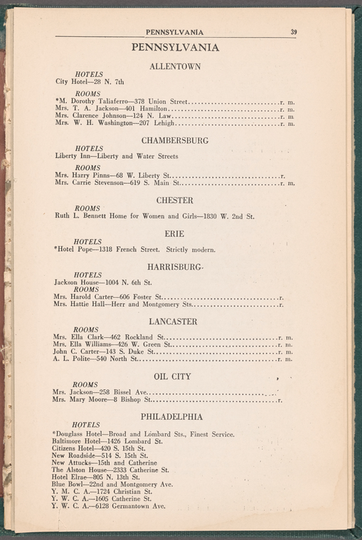
While white travelers concerned themselves mostly with directions and destinations, Black travelers had many more logistics to be concerned with. Discrimination was commonplace along the roads, and a stop at a particularly hateful place could put them in danger. Some African Americans were advised to travel at night, and below the posted speed limit, in order to avoid being noticed and stopped by police. Traveling with white people was even more likely to attract police attention. Black travelers faced discrimination at gas stations and rest stops, which compelled them to travel with portable toilets.5 To circumvent some of the perils of travel, African Americans consulted traveler’s guides such as the famous Negro Motorist's Green Book, published annually from 1937-1964. These books contained lists of businesses which would admit Black customers: hotels, rooms for let, gas stations, barbershops, restaurants, all sorted by state and city. This was an invaluable resource for long distance travel.
This guide would have been useful to Black attendees of the 1931 conference. The conference organizers requested that all speakers be in attendance at all meetings. The organizers offered to help speakers find housing--a significant accommodation. The previous year, a Swarthmore conference on race relations was not held because the organizers were not able to offer housing on campus, over concerns of controversy for accommodating Black attendees. Despite the organizers’ offer, it is possible that attendees would not have been comfortable staying at Bryn Mawr. There were not many Black people on Bryn Mawr’s campus; although Bryn Mawr’s first Black students, Enid Cook (Class of 1931) and Lillian Alfrebelle Russell (Class of 1934) were attending the college, they were not permitted to live on campus, and were housed by local Black families. Some attendees, such as W.E.B. Du Bois, still chose to stay in Philadelphian housing. The map above includes a collection of Philadelphia hotels listed in the 1930 edition of Hackley & Harrison's hotel and apartment guide for colored travelers. It simultaneously indicates places that Black students may have resided in during the conferences, and serves as a reminder that those locations were some of the only places they would have been able to stay in comfort.6
Related reading: Traveling While Black: behind the eye-opening VR documentary on racism in America.
Maps and Mapping Devices
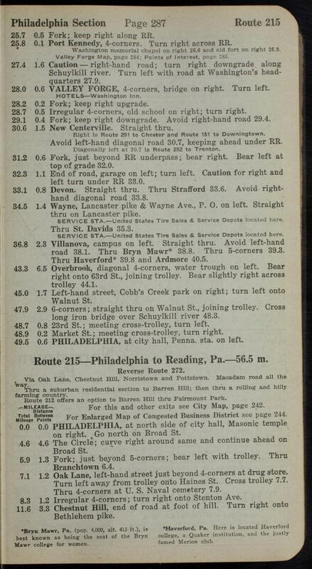
Today, Americans largely rely on cars for convenient and personalized travel. But observe the network of light red highways that features in the map’s background: a century ago, none of these routes existed. At the turn of the century, roads were relatively short, undocumented, and in disrepair. Cross-country driving was such an endeavor that for some it became a daring kind of tourism. There were no road signs and no road maps; depended relied on the use of a compass, following railroad tracks, and frequent speaking to locals. Americans had mental maps of their local area, and relied on trains to take them for further distances. This knowledge gap was filled by route guides, the precursors to road maps. Students attending the 1924 and 1931 conferences might have used a route guide to find their way. Among the guides available between 1900 and 1930: the Automobile Green Book, the King’s Official Route Guide , the Interstate Automobile Tourists’ Guide, and the “earliest and most popular” Official Automobile Blue Book (1901-1929).
Why no road maps? Current maps can get away with the vast length covered on each page because they can generalize roads. Modern maps benefit from consistent road identification and signage, which was not in existence a century ago. To overcome this, route maps like the Official Automobile Blue Book (hereafter referred to as OABB) operated with a hierarchy of three types of maps and directions. The maps which covered the most distance, and were the least detailed, were “skeleton” maps. These looked akin to modern road maps, with interconnected cities represented as points; however, the lines actually represented segments of road, each labelled with an identification number that could be looked up for details on that area. On the next level down, the OABB included supplemental maps of major urban areas, which displayed the main routes of the city, as well as routes between major intersections in cities. The only streets labeled here were the ones that were listed in the route directions. Finally, the OABB contained route directions, which provided the heart of the book’s detail. Route directions were turn-by-turn descriptions, using landmarks and distances traveled as a guide for where to turn--kind of like a modern map app’s narration! Each route had to be described twice, to make a round trip, but they would use the same landmarks.
This amounted to a very precarious system. This system required that the user continually reset their odometer--which was not automatically included in early vehicles--or keep a pencil and paper nearby, to keep track of the distance. If the user lost track of the distance, missed a turn, or if a landmark no longer existed, they could become lost very quickly. A notable difference between modern map app narration and the OABB is that the latter would not recalculate routes! This mapping process required such attention that it would usually have to be done by the passenger. But fortunately, cars would rarely go more than 30 mph because of poor road conditions, laws, and the restrictions of early motor engines. The downside, naturally, was that a journey that today would take an hour, would a century ago take many times that long.
Possible car routes are not displayed on the maps, as they would require a significantly deeper level of information on contemporary roads. Instead, distances not covered by trains are represented as a simple line; the preceding information exists to establish what a demanding task crossing that space was.7
1. Raphael, Steven and Michael A. Stoll, "Can Boosting Minority Car-Ownership Rates Narrow Inter-Racial Employment Gaps?" Brookings-Wharton Papers on Urban Affairs:2001, edited by William G. Gale and Janet Rothenberg Pack, Brookings Institution Press, 2001, pp. 99-100. ↩
2. "The Only African American Automobile Company," Our American Story, National Museum of African American History & Culture. ↩
3. Sugrue, Thomas H., Driving While Black: The Car and Race Relations in Modern America," Automobile in American Life and Society. ↩
4. Blakemore, Erin, "How Automobiles Helped Power the Civil Rights Movement," Smithsonian Magazine, February 28, 2020. ↩
5. Sugrue, Thomas H., Driving While Black: The Car and Race Relations in Modern America," Automobile in American Life and Society. ↩
6. Driskell, Jay, "An atlas of self-reliance: The Negro Motorist's Green Book (1937-1964)," National Museum of American History, July 30, 2015. ↩
7. Bauer, John T., "The Official Automobile Blue Book, 1901–1929: Precursor to the American Road Map," Cartographic Perspectives 62, 2009, pp. 4-27. ↩


